
Publication, 2026-11-11
Green space exposure and mortality in the Florentine plain
Open access article in Stochastic Environmental Research and Risk Assessment, published in April 2026
Increasing urban green space is a preventive public health strategy. An open access article published in April 2026 in Stochastic Environmental Research and Risk Assessment shows that sufficient exposure to residential green space in the Florentine plain (Tuscany, Italy), measured with the satellite index NDVI within 300 m of homes, could prevent up to several hundred deaths per year among adults over 35 and reduce social and health inequalities. geoLAB is among the authors of the study.
Study area and data
The study covers 452 km² and eight municipalities: Florence, Bagno a Ripoli, Calenzano, Campi Bisenzio, Lastra a Signa, Scandicci, Sesto Fiorentino and Signa, divided into 3,412 census tracts. Exposure to green space is measured as the mean Normalized Difference Vegetation Index (NDVI) within 300 m of each census tract, derived from Landsat satellite imagery of 2015. The health data are the deaths recorded in 2021 among adults over 35, combined with an index of socio-economic deprivation.
Vegetation currently covers on average 41% of the area within 300 m of any point in the eight municipalities, from 38% in Florence to 61% in Bagno a Ripoli.
Five greening scenarios
The authors compared five hypothetical scenarios and estimated the deaths that each would have prevented in one year:
- NDVI of at least 0.5 in every census tract: 346 preventable deaths, 4.9% of all deaths
- NDVI of at least 0.7 in every census tract: 877 preventable deaths, 12.5% of all deaths
- Absolute increase of 0.1 in NDVI: 310 preventable deaths, 4.4% of all deaths
- Relative increase of 20% in NDVI: 25 preventable deaths, 0.4% of all deaths
- World Health Organization greenness target: 47 preventable deaths, 0.7% of all deaths
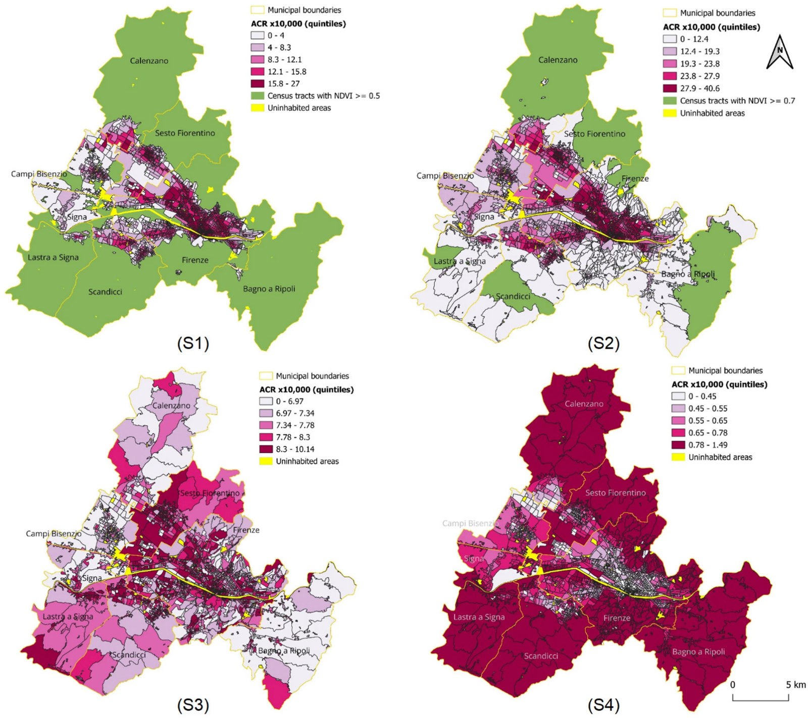
Preventable deaths per 10,000 inhabitants by census tract in scenarios S1 (NDVI of at least 0.5), S2 (NDVI of at least 0.7), S3 (absolute increase of 0.1) and S4 (relative increase of 20%). Source: Baccini et al. (2026), CC BY 4.0.
Uncertainty
The exposure-response function comes from a Bayesian meta-analysis, and the uncertainty is propagated with Monte Carlo simulation. The uncertainty intervals are wide, but in the scenarios analysed the probability that more green space has an impact on mortality greater than zero exceeds 90%. A global sensitivity analysis shows that the main source of uncertainty is the hazard ratio that links NDVI to mortality, while deprivation and the stochastic redistribution of deaths to census tracts have a minimal effect.
Social equity
The largest numbers of preventable deaths are in Florence and Sesto Fiorentino, where exposure to green space is currently lowest. The more deprived neighbourhoods have lower levels of green space. Scenarios based on a minimum threshold of greenness benefit the more deprived population most, while a proportional increase of 20% mainly benefits neighbourhoods that are already green.
Indications for policy and urban planning
- Beyond generic metrics: satellite indicators such as NDVI need to be combined with the actual types of vegetation (trees, shrubs) to plan effective and sustainable interventions.
- Priority to vulnerable areas: planting trees and creating parks first in dense and socially deprived neighbourhoods gives the largest public health gain.
- Historic centres: in complex contexts such as Florence, green roofs, green walls and pocket parks can overcome planning and heritage constraints.
Reference
Baccini M., Burbui G., Nuvolone D., Borghi C., Lachi A., Mancuso S., Chirici G. (2026). Green space exposure and mortality in the Florentine plain: preventable deaths at the census tract level and uncertainty analysis. Stochastic Environmental Research and Risk Assessment, 40:99. https://doi.org/10.1007/s00477-026-03217-y
The figures on this page are adapted from the article, which is licensed under CC BY 4.0. The maps were cropped and rearranged.